Digital Agriculture Laboratory
UC Davis Logo
UC Davis Logo
Digital Agriculture Laboratory  | College of Agricultural and Environmental Sciences | College of Engineering

Digital Agriculture Laboratory

College of Agricultural and Environmental Sciences | College of Engineering
  • UC Davis

Main navigation (extended config)

  • Home
  • RS Data Base
    • 1- Data Base Content
    • 2- Overview
    • 3- Platforms
      • 3.1. Unmanned Aerial Systems (UAS)
      • 3.2.Manned Aircraft
      • 3.3. Satellite
    • 4- Sensors
      • 4.1.  RGB
      • 4.2. Multispectral
      • 4.3. Hyperspectral
      • 4.4. Thermal
      • 4.5. Lidar
      • 4.6. Radar
      • 4.7. Acoustic
    • 5- Applications
      • 5.1. Water Status
      • 5.2. Disease control
      • 5.3. Yield mapping and prediction
      • 5.4. Nutrient management
      • 5.5. Salinity
      • 5.6. Phenotyping
    • 6- Data processing and analysis
      • 6.1. Preprocessing
        • 6.1.1. Radiometric Calibration
        • 6.1.2. Georeferencing
        • 6.1.3. Mosaicing
        • 6.1.4. Point cloud and Digital Surface Models
      • 6.2. Processing
        • 6.2.1. Noise removal and segmentation
        • 6.2.2. Raw Feature Extraction
      • 6.3. Analytics
        • 6.3.1. Multicollinearity
        • 6.3.2. Feature engineering and feature selection
        • 6.3.3.Data mining
      • 6.4. Regression\classification
    • 7- Course of Action
  • Decision Support Tools
    • GDD Calculator
    • Radiative transfer Modeling
    • When to fly?
  • People
  • Research
  • Publications
  • Extension
  • Galleries
  • Open Positions
  • News
Breadcrumb
  1. Digital Agriculture Laboratory
  2. Decision Support Tools

Decision Support Tools

This page includes decision-support tools and web applications developed at the Digital Agriculture Lab at UC Davis. Farmers can use these tools to make wise data-driven decisions throughout the season.

Sun-View Geometery

When to fly?

Discover the optimal time for drone mapping by providing your location and the desired date for capturing high-quality aerial imagery.


simulation of radiative transfer modeling with prospect pro

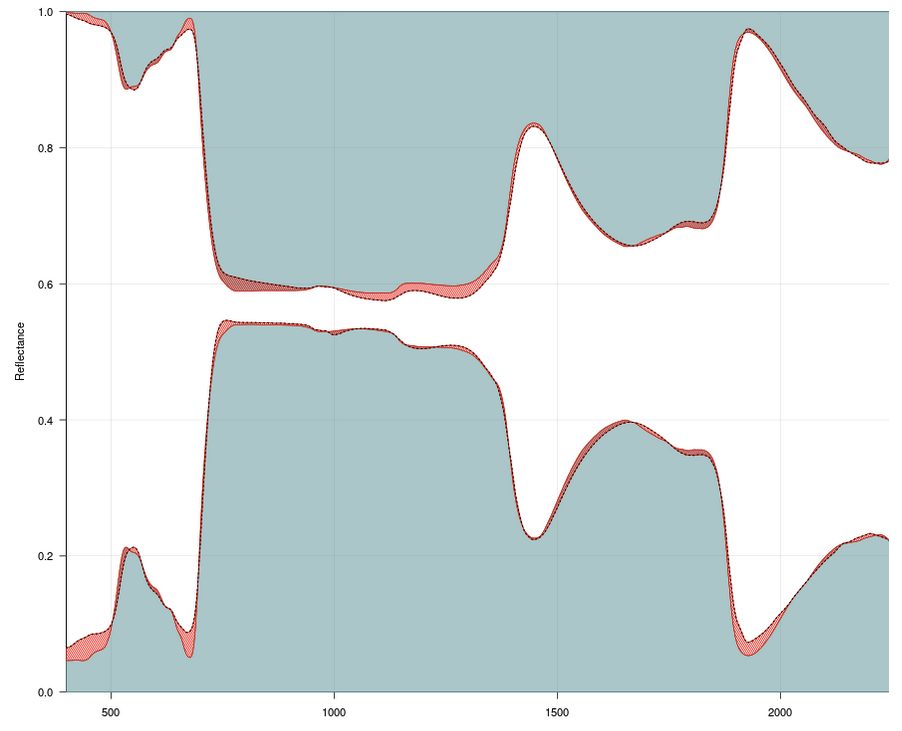
RTM Simulator: Plant Traits from Spectra

This web application provides an interactive visualization of radiative transfer modeling based on the PROSPECT PRO model.

Satellite_Insight

Satellite Insight

Unlock precise, remote sensing analytics for your crops with ease. Using Sentinel-2 imagery and the PROSAIL model, this tool provides vital, data-driven insights.

GDD

GDD Calculator

This web app offers a quick and easy way to calculate Growing Degree Days (GDD) for your crops. Just input your location and crop type, and It will crunch the numbers. Make smarter farming decisions by knowing the best time for planting, irrigating, and harvesting.


UC Davis footer logo

University of California, Davis, One Shields Avenue, Davis, CA 95616 | 530-752-1011

  • Questions or comments?
  • Privacy & Accessibility
  • Principles of Community
  • University of California
  • Sitemap
  • Last update: November 5, 2024

Copyright © The Regents of the University of California, Davis campus. All rights reserved.

This site is officially grown in SiteFarm.